Showing posts with label Gulf Coast. Show all posts

Thursday, November 10, 2011

Coastal Geology & "Engineered Avulsions"

So, I'm in grad school now and that's eating up a whole ton of time. I'm going to take one of my projects and post a bit of it on the ole blog because I think it's interesting.

The assignment for a class on coastal geology was to take a scientific paper, write your own abstract and make a presentation to the class. Two of my projects were Blum and Roberts 2009, "Drowning of the Mississippi Delta due to insufficient sediment supply and global sea-level rise" (quite the pessimistic title, especially for a scientific journal). Here's a writeup by Dr. Len Bahr and here's the original paper [PDF] as published by Nature Geoscience.

The second one I did was was Mohrig, Kim, et. al. 2009, “Is It Feasible to Build New Land in the Mississippi River Delta?”. Note that the second paper directly references the first. Here's a writeup from Dr. Bahr and here's the supplemental material from Eos / American Geophysical Union (Thanks, Maitri and Helena on the assist!).

Here are my slides with my presentation notes interspersed. I skipped a couple slides in the middle, but this should be the gist of it.


So, the last time I presented, we went through how screwed South Louisiana is. We went through Blum and Roberts' extremely pessimistic projections for coastal rebuilding efforts. Well, now I'm going to present an alternative scenario.

Mohrig, Kim, et. al. presented their paper shortly after Blum and Roberts presented theirs.

We've all heard the dire predictions. 10,000+ km^2 of land loss over the next century. Look at all the red on that map and of course red = bad.

We should just give up and move to Cleveland, right?
Let's take a closer look at one of those "red" maps. You see a bit of green. The Atchafalaya basin is still growing. One lobe is the main Atchafalaya. The other is Wax Lake, which is actually artificially created.


What is Wax Lake? In 1941, there were big river floods and people were worried about Morgan City being inundated, so the Corps cut a channel (the Calumet Cut) to divert ~30+% of the water away from Morgan City. The Corps cut the channel, Morgan City was saved, and everyone forgot about the cut and left it at that. And then something interesting happened...

(Progression of images of delta building; note Belle Isle Salt Mine)


(Some images omitted for post)


Note that all this delta building took place in an area that WAS affected by oil and gas activity, that WAS affected by major erosion from Katrina/Rita, etc.


So, in the paper, Mohrig, Kim, et. al. constructed a model of delta building based off Wax Lake, then backchecked their results on the actual Wax Lake delta. Here's the model results 1941-2005 (the two sets of lines represent variation in % sediment load captured by Wax Lake vs. main Atchafalaya).
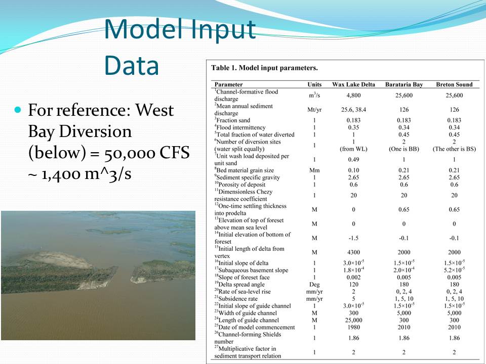

Mohrig, Kim, et. al. then modeled two major diversions in Lower Plaquimines Parish. Note that these diversions are AT LEAST an order of magnitude greater than West Bay, which is the largest diversion project built to date.


So, here are the results. From 2010-2110, considerable land is created. One important note: the diversions are only opened during flood events. During low river levels, the diversions are closed. If you "save" New Orleans, but kill the Port of New Orleans, you've sorta shot yourself in the foot. We can both save the city and keep the river navigable.
Another thing to note: everyone says, "we just gotta blow up the levees" and that will fix everything, right? Well, not quite. Mohrig, Kim, et. al. said that wouldn't give you a deep enough channel (to capture the coarsest-grain sediment) and you don't really have enough control over the river dynamics.

They advocated an "Engineered Avulsion" (*I love this term*), like the Old River Control Structure.

Here's another view of an "Engineered Avulsion"


That's the presentation. There was some nice discussion at the end of the presentation. Gotta run to class now.

UPDATE: Fixed some minor typos.

Here's the full progression of images on the Wax Lake building. Found it via this Field and Stream article: Wax Lake Delta: Accidental Eden in the Atchafalaya. I reformatted the images to make them easier to read, but the raw source has a lot more slides on it.

Here's a presentation on "Optimizing Engineered Avulsions". Once again, I love the term "Engineered Avulsion."

Here's the definition of an "Avulsion": In sedimentary geology and fluvial geomorphology, avulsion is the rapid abandonment of a river channel and the formation of a new river channel. Avulsions occur as a result of channel slopes that are much lower than the slope that the river could travel if it took a new course. (Wikipedia)

Wednesday, August 8, 2007

Weird News

Kangaroos on Hwy 90. Poor Eddie Farve will now have to combat kangaroos in his shorts.

Mike Vick Chew Toy. Payback is a bitch! Oh yeah, and the SCLC is honoring Vick.

Buffalo man lives in underground bunker. Sort of cool, actually.

Young Republican Official charged with gay rape. And he seems to have a history of these things... So that's how it gets started...

Wednesday, May 30, 2007

Trip to Mars


Well, not that Mars. I'm talking about the Mars Platform. It's a big platform about 190 miles south of New Orleans. It's a hive of activity. I had some work to do out there. I stayed out there for 2 days and on the return flight, I brought a disposable camera along. Here are some of the photos I took.


This trip, I flew back in a Eurocopter EC-135. It's a tiny little helo that's mainly used for emergencies (medical, supplies, people, etc.). I usually fly in on one of the big helos (like the Bell 214). I like the Bell 214. It's so stable it feels like the earth is being lifted up with the helicopter. It's so big, it holds 17 passengers and the only reason it's not more is FAA regulations require a stewardess for any more. Because of it's size, it's my favorite helicopter to fly out on. The Eurocopter, not so much. It's not that bad, but you do get a little queasy. I also made the situation worse by waiting on the helicopter in the galley (sort of like hanging out in Galatoire's kitchen before going on a Tilt-a-whirl). Not fun.


Strapped in and ready for takeoff.


More of that great view. It was a little hazy that day, so you can't see the horizon like you normally can.


Algae on the water. I'm not 100% sure, but I think this is red algae in the Dead Zone. If someone can confirm this for me, I'd appreciate it.


The Shelf. After a while, the waters get shallow. That's when you hit the shelf. It's the shallow water closer to shore. The water just changes color instantly. I'm not sure how much of the color change is due to the depth and how much is attributable to silt from the Mississippi River, but it's amazing to see the water change so quickly.

The second half of the images will come shortly. If you want to see higher quality photos, please check this link out. Also, now that I've got things sort of figured out, the rest of the photos shouldn't take nearly as long.

UPDATE- Fixed it. Now, I just hope it stays fixed.

Saturday, March 31, 2007

My Trip to the Mississippi Gulf Coast


S.S. Camile, still there.

About a week ago, I went over the Mississippi Gulf Coast. I wanted to visit some of my relatives who spent Katrina up a tree watching a home that had been in their family for generations and make it through Camile disintegrate under the fury of the waves.

I, like many New Orleanians, spent many vacations on the Coast when I was growing up. I was especially eager to visit because I had seen the Mississippi Gulf Coast less than 2 weeks before Katrina hit. I was doing a survey for an engineering firm I worked at over the summer before my senior year. We were doing some work for the port of Gulfport and I remember thinking, "Gee, all those empty lots from Camile have finally been filled in. It looks so good."

Well, about two weeks later Katrina hit and you know the rest.


Steps, all that remain of many homes.

Another reason I wanted to go to the Coast was to see how true (or should I say, how false) the, "well, Mississippi is recovered, why is New Orleans still asking for money" thought process is.

I toured the ENTIRE coast over the course of a day. From Waveland to Ocean Springs and everything in between. We had to navigate around the missing bridges in Bay St. Louis and Biloxi. Spent a lot of the afternoon in Ocean Springs, too.

I brought my good ole Canon AE-1, one of the greatest cameras ever made. It was my grandfather's and it's still going strong. Load it up with black and white film and you'll be amazed at the photos it produces.

I was amazed at the devastation. I sort of assumed that Bay St. Louis and Waveland took the brunt of Katrina and the areas closer to Alabama were largely spared. Boy, was I wrong. It's also hard to see exactly how much was lost, unless you knew what it looked like before Katrina.

Here are some of my observations

Differences between Gulf Coast and NOLA:
* No abandonments- In New Orleans, some people just evacuated and never returned. That just hasn't happened over there.
* Excellent government (but has remarkably little bearing on the recovery). Their politicians aren't stuffing money into freezers. Not that it's helped that much. A lot of those places have EXCELLENT schools. In Ocean Springs, all the schools are "5 out of 5" (MS rating system).
* Crime. They've had some problems in their FEMA trailer parks, but they got a handle on things early before crime ever got a toehold. The same can't be said of the Big Bloody.
* Better connection between recovered zones/struggling zones. In New Orleans, there's the "Isle of Denial" and there's the "Magical Misery Land." There's a lot less interaction than there should be. In Mississippi, there's a much better connection.
* Small biz's doing slightly better in NOLA. In Louisiana, there are more tourists, so small businesses at least have enough to break even. In MS, they're still struggling (except for the big casinos).
* FEMA flood plain. FEMA didn't wuss out over there. The BFE (Base Flood Elevations) are extremely high (as they should be). We're talking about 15-20' above grade. Some places even higher. What is getting rebuilt is getting built high.

Similarities:
* Ancestral homes, don't have $ to rebuild. So many of the homes were inherited from one generation to another.
* Inflated construction costs.
* Stuck (no $). Their version of the Road Home is better, but still not great. Also, their is the simple fact that, especially factoring in inflated construction costs and high BFE's, it simply isn't enough money to rebuild.
* Islands of recovery, islands of despair.
* Big business recovers well. In Louisiana, the oil companies got their infrastructure repaired in short order, despite massive damage.
* The "New Normal."
* Dilapidated, abandoned buildings.
* They have a Lower 9, Claiborne Ave, Lakeview (& Magazine Street). Their Lower 9 is a neighborhood of Vietnamese and Polish fishermen just Northeast of the Port of Gulfport. The homes were handed down from generation to generation. Many were little more than shacks, but they were all owned. The main business road in Gulfport looks like Claiborne Ave. (lots of shuttered and abandoned businesses). They have a Lakeview (bedroom community of brick buildings that are still intact, but deserted). Main Street in Ocean Springs, which is way up on a hill, is filled with boutique stores, art galleries, bars, and great restaurants. Reminds me of Magazine Street.
* Still have lots of legal battles (but different targets). We're suing the Corps. They're suing their insurance companies. Insurance over there was far worse than in Louisiana, at least in my opinion. State Farm was, under the circumstances, fair with us. My relatives also had State Farm and they were treated like criminals. I was shocked at that they were describing the same company.
* Good food. I had a late lunch/early dinner at the Beau Rivage. Excellent! I stuffed myself. I'd recommend to anyone. A lot of the chefs had New Orleans roots. You could tell by the very flavorful (but not overly hot) food.


The beach, just as beautiful as ever.

I really enjoyed my trip. I learned a lot, I ate great food, and I got to see my relatives. If things get to hairy in New Orleans, I'd definitely think of moving to Ocean Springs. It's a nice little town.

If someone tells you why can't Louisiana be like Mississippi, you tell them that we pretty much are like Mississippi.

I've got a bunch more photos that I want to post. Blogger's software is acting up on me and it's taking a hell of a long time to upload these high quality photos. I still need to get another roll finished off. That roll has the best photos. I'll get them up eventually.