The assignment for a class on coastal geology was to take a scientific paper, write your own abstract and make a presentation to the class. Two of my projects were Blum and Roberts 2009, "Drowning of the Mississippi Delta due to insufficient sediment supply and global sea-level rise" (quite the pessimistic title, especially for a scientific journal). Here's a writeup by Dr. Len Bahr and here's the original paper [PDF] as published by Nature Geoscience.
The second one I did was was Mohrig, Kim, et. al. 2009, “Is It Feasible to Build New Land in the Mississippi River Delta?”. Note that the second paper directly references the first. Here's a writeup from Dr. Bahr and here's the supplemental material from Eos / American Geophysical Union (Thanks, Maitri and Helena on the assist!).
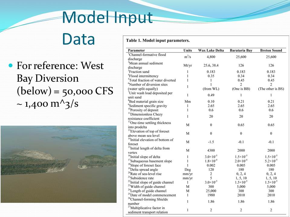
Here are my slides with my presentation notes interspersed. I skipped a couple slides in the middle, but this should be the gist of it.

So, the last time I presented, we went through how screwed South Louisiana is. We went through Blum and Roberts' extremely pessimistic projections for coastal rebuilding efforts. Well, now I'm going to present an alternative scenario.

Mohrig, Kim, et. al. presented their paper shortly after Blum and Roberts presented theirs.

We've all heard the dire predictions. 10,000+ km^2 of land loss over the next century. Look at all the red on that map and of course red = bad.

We should just give up and move to Cleveland, right?
 Let's take a closer look at one of those "red" maps. You see a bit of green. The Atchafalaya basin is still growing. One lobe is the main Atchafalaya. The other is Wax Lake, which is actually artificially created.
What is Wax Lake? In 1941, there were big river floods and people were worried about Morgan City being inundated, so the Corps cut a channel (the Calumet Cut) to divert ~30+% of the water away from Morgan City. The Corps cut the channel, Morgan City was saved, and everyone forgot about the cut and left it at that. And then something interesting happened...
 (Progression of images of delta building; note Belle Isle Salt Mine)

 (Some images omitted for post)


Note that all this delta building took place in an area that WAS affected by oil and gas activity, that WAS affected by major erosion from Katrina/Rita, etc.

So, in the paper, Mohrig, Kim, et. al. constructed a model of delta building based off Wax Lake, then backchecked their results on the actual Wax Lake delta. Here's the model results 1941-2005 (the two sets of lines represent variation in % sediment load captured by Wax Lake vs. main Atchafalaya).
Mohrig, Kim, et. al. then modeled two major diversions in Lower Plaquimines Parish. Note that these diversions are AT LEAST an order of magnitude greater than West Bay, which is the largest diversion project built to date.

So, here are the results. From 2010-2110, considerable land is created. One important note: the diversions are only opened during flood events. During low river levels, the diversions are closed. If you "save" New Orleans, but kill the Port of New Orleans, you've sorta shot yourself in the foot. We can both save the city and keep the river navigable.
 Another thing to note: everyone says, "we just gotta blow up the levees" and that will fix everything, right? Well, not quite. Mohrig, Kim, et. al. said that wouldn't give you a deep enough channel (to capture the coarsest-grain sediment) and you don't really have enough control over the river dynamics.
  They advocated an "Engineered Avulsion" (*I love this term*), like the Old River Control Structure.
  Here's another view of an "Engineered Avulsion"
That's the presentation. There was some nice discussion at the end of the presentation. Gotta run to class now.
UPDATE: Fixed some minor typos.
Here's the full progression of images on the Wax Lake building. Found it via this Field and Stream article: Wax Lake Delta: Accidental Eden in the Atchafalaya. I reformatted the images to make them easier to read, but the raw source has a lot more slides on it.
Here's a presentation on "Optimizing Engineered Avulsions". Once again, I love the term "Engineered Avulsion."
Here's the definition of an "Avulsion": In sedimentary geology and fluvial geomorphology, avulsion is the rapid abandonment of a river channel and the formation of a new river channel. Avulsions occur as a result of channel slopes that are much lower than the slope that the river could travel if it took a new course. (Wikipedia)
1 comment:
If you keep this up people will start to think you're a geologist...
Renegade Seismologist from the 8th Dimension (Tulane Geology '84)
Post a Comment